This village has a comprehensive history dating back to before the Romans. Little of that period is in evidence but its advantageous and possibly defensive position between the two rivers, and its later proximity to Roman Castleford and the Ermine Street by-pass to York can leave us with little doubt that the area was inhabited. Could it be that Cartimandua, Queen of the Brigantes passed here, that same Queen who having left her husband as hostage with the Romans to obtain her own release then immediately turned round and proceeded to do battle with the Romans her husbands jailers.
Once again we can only surmise that the area was worked during the dark ages to the Domesday period by Britons, Saxons and possibly Norse settlers.
It will be possible to see that development from a grouping of small hamlets into a village made up of a concentric manor within a manor evolved initially from its geographical position. Later shaped by the Church, influential leaders and outside historical events up to the present day. The larger village as such did not have a defined village centre, probably because of its size. A village centre was to develop in the inner demesne (Mickletown – Magna Villa) with the mill, smithy, brickworks and central Manor house.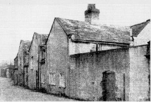
The hand of history on this village continued throughout the mediaeval period in the form of Lords of the Manor who would have overseen the three field crop rotation system of agriculture. The plague left its mark as did the Wars of the Roses, and 200 years later the village new all about the Civil War and later still the Parliamentary Enclosure awards.
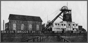
Further developments were the improvements to river traffic following uprating of the Port of Goole giving better access to the sea. The construction of the three rail lines and development of two coal mines followed workings of a number of small pits.
Later, the introduction of industrial and social reform. For instance, the traditional church was not insulated from change with the advent of a number of non-conformist chapels. Victorian Methley saw increases in the population with the new mines and access to developing towns.
Then came two world wars. As with the rest of the country, Methley was sorely affected, the village was to play a small part in the second war. Three major strikes in coal-mining.
 Agriculture was now at its zenith. Changes continued with the transport systems, including completion of the M62.
Then came closure of the mines and working coal seams by opencast methods. Reductions in agricultural needs more recently and finally the increased demand and supply of new homes leading to the accelerated development of housing estates.
Place Names of Methley (Source: Place Names WR of Yorks, AH Smith Camb U Press)
Carr Hall – os 1841 near the Aire at Mickletown
Carr Houses – on the Calder near Methley Junction
Cringlesworth – Crynglesfurthe pasture 1559, ford at the loop in the Calder
Ear Moits – confluence
Hungate – where hounds were kept
Methley Mires – swamp, Mires 1339, Myers 1373, Myerside 1386
Mickletown – Magna villa de Methley 1354 denotes part of village
Morehouse – Morehouse 1405, Lowmoor, Southmore side
Thorpe – by the Kelder 1410, Thorplidyate – outlying farmstead
Woodrow – row of houses near the wood, Woodrowe 1375
Allerton Ferry – the ferie 1592, boatstake 1759, stake where the ferry was moored
Bond House – Bond Garth 1809
Kirkside – Kirkside 1368 Churchfield
Coney Moor – Coney Moor 1723 (rabbits)
Crooked Park – Crooked Park 1541
Methley Grange – 1841 os
Stoney Lane – Stoniloine 1368
Watergate – road leading to Calder
West Hall – West House 1537
Whitecrosse – Whitecrosse 1373
Whitehouse Farm-
Willow Grove –