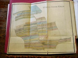
As with all villages, common land in the Manor of Methley was sub divided into strips probably based on the mediaeval ‘Three Field System’ of farming (1 year corn crop, 1 year root crop and1 year fallow). Management of the land holding system was by the Leet or Manor Court and we know from early records that Met hley had 4 major fields, each field, split into this strip system. These were :- East Field, West Field, Church Field and Moorhouse Field.
The fields were places where people talked while they worked, and they worked together. The countryside was busy not empty. You could tell the time of day by the regular comings and goings of common flocks and herds along the village roads, and the time of year by their disposition in the fields and pastures. A jury sat to ratify them and to hear complaints.
Jurors and fieldsmen met at an inn, and in public with an audience of commoners. They drank together with the rest of the company or in earshot of them, then they had orders cried round the village before they were nailed to the church door.
Once a year the whole parish met together and walked the bounds naming the field marks, remembering the line between what was theirs and what belonged to the parishes around them. Every year after harvest the field officers opened up the wheat field to the gleaners and cried the hours of gleaning round the village. After which the herds came into the stubble followed later by the sheep. The pigs and geese picking up fallen grain in the lanes and streets.
Resistance to Enclosure created to following rhyme regarding the injustice of it all:-
The fault is great in man or woman
Who steals a goose from off a common;
But what can plead that mans excuse
who steals a common from a goose? Laxton, Nottinghamshire
Problems of protecting strips from misuse by other owners e.g. animals grazing on other holdings and land drainage are well recorded in the book ‘History of Methley’ and no doubt these problems were experienced throughout the country.
A probable result of this, along with the need to improve output, was a series of Acts approved by Parliament in the late 18th century giving power to those who could fence or enclose specified land could claim it. Invariably this would be the most wealthy and acquisitive landowner.
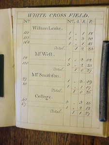
The enclosure awards made by the Commissioners were subsequently made possible on the basis of accurate land surveys. One such survey was made for Methley by Wm Pape, Surveyor of Wakefield in 1773. The survey book showed that Methley now had 8 areas :- Low Field, Oaks Field, Church Field, Whitecross Field, Leatherforth Ings, Thorp Ings, Gamisker Ings and North Ings.
Most villages increased their holdings throughout the mediaeval period by the gradual clearance of woodland and heath, known as ‘assarting’. It would seem that in the case of Methley additional land was developed by reclaiming ings (fens) as civil works were by now improving river draughts and working canal cuts giving improved river and canal banks.
Displayed are selected photographs of the survey book which include accurate drawings of the strips with numbered identification on the folding plans. Then each plan was followed by a breakdown of the owners, with areas quantified into acres, roods and perches and summarised at the end of the survey. The lettering of the books would appear to have been written by hand but I suspect the layout and titles would have been prepared with the aid of a serifed stencil.
It was reported that some 5000 instances of enclosure took in some 6 million acres of common fields from 1760 onwards. The result, it was claimed was an increase in poverty levels in the countryside forcing a shift in the population to the coal mines, new factories and developing towns and cities. It could be argued that with the drift and increases of the population to the towns, the old feudal system of farming was incapable of feeding this increasing market and as a result an increase in the size of farms was required to make them more productive.