As walks go, its the big one in Methley, it is of course the walk round the parish boundary.
Starting at the waterbridge over the Calder at Three Lane Ends along with trusty Oscar who was straining at the leash and who, on release went like a bullet down the bank, across the flood sluice gate and along the Methley side of the river bank. 
He immediately started to cover the ground in grid formation, the experts say that field dogs have to be thoroughly trained to do this – well this Springer did it naturally without any field training as I suspect most of them do.
The walk is on top of the flood bank construction and offers an unobstructed view of Dunford House and the gravel extraction works on the left.
Ignored by the grazing cattle the walker will cross two heavy duty pipe outlets discharging clear gravel quarry water into the river. I don’t know what volumes are going into the river but I suppose over the last 30 odd years it will amount to some millions of gallons.
Further along the 2 oxbow lakes come into view camouflaged by their trees and bushes, in the gaps its possible to see the small wooden fishing jettys. Its hard to imagine how the river made progress in ancient times along these meanders.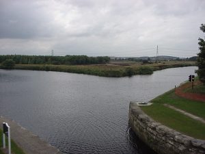
We’ve now reached the confluence with the Aire – looking across, the combined rivers continue towards the flour mill and weir at Castleford, to the left the lock gates which by- pass the weir are closed next to an adjacent disused lock gate. I’ve been here before and it is usually a busy throughway for waterway traffic.
Behind, the Methley Mires flatlands stretch back, and whilst it is now well cultivated it is easy to see how unworkable it would be without the protection of the floodbank and the long term drainage that is now in place.
Continuing now along the Aire, under the pylons and along the straight that leads to the boatstake track to Boat Lane and the site of the demolished Methley Grange. The dog’s getting quite excited – there’s lots of evidence of rabbits in this area. Across the river the Boat pub at Allerton Bywater looks attractive with customers sat outside.
Our journey is now slightly back from the river and points up to Kippax locks (why Kippax locks?) where the river bisects upstream to become the canal and river. The locks are well maintained but no resting and we now head on the straight to Pit lane and the footbridge on the site of the old half penny bridge. The staithe on the other bank looks disproportionately large against the footbridge and the old canal basin.
We are now on the crumbling overgrown canal path which circumferences the Savile pit stack extension and head towards the Savile basin where the route takes an inland course because the donkey bridge and the next wooden swing bridge have been dismantled.
We recover the canal path from the Methley North station detour and press on to Lemonroyd locks. At this point I’m not exactly sure which is the parish boundary but I take it to being Fleet beck and follow this along the valley ridge to the LMS line. Pass under the bridge and relocate the beck as it enters the culvert.
The walk continues along the beck, much more silted and overgrown than when I remember, it doesn’t bother Oscar though he makes himself at home in the beck and its surrounds. Its still an attractive but little known feature of this village.
We are now crossing the old private road to Water Haigh pit and reach the equally attractive footbridge leading to Knowles’ farm and Oulton. The route turns left at the footbridge and makes for the A639 which we cross and follow the bridleway leading to the parting of the Manor.
The first elevation of the walk and we pass an old stone quarry and on reaching the top we open out onto Moss Carr. At this point our route does not follow the treeline to Hungate but we select a path flanking the farm (dog on leash) walking parallel with, then across the M62 footbridge and join Newmarket lane.
Across the road a bridleway sign directs me along a track which skirts the old Newmarket pit and brings us out at the Calder. Left turn walking eastwards brings us under the M62 and on to Frost dam – on the map its recorded as Penbank Lock which is how it is known in Altofts – I have to keep my eye on Oscar – hes taking an interest in the dam.
Its the last furlong now and its not easy going not too many walkers along here – fortunately the the first railway bridges can be negotiated through the arches alongside the river.
The third one however (with the waterbridge now in view) which is the disused line has to be climbed and accessed past a derelict signal box. The dog appears to be just as active as when we commenced.
On this embankment I was amazed to find a venus flycatcher growing among the briars in the railway ballast ashes. I’d come across lots of the usual flora e.g. cow parsley (gypsy bread), red campion, hedge bindweed, burdock and the large red plant that distributes its seeds by exploding on touch (himalayan balsam?).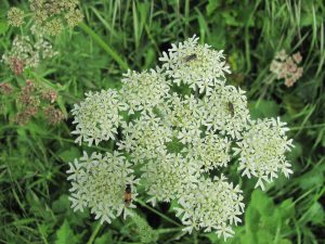
Straight on now, down the embankment and along the river to the start of the parish walk at Three Lane Ends. Here we have a further 2 miles to go to get home to Smawthorne Lane.
I reckon the dog does 4 miles for every mile that I cover and he must have done something in excess of sixty miles.
After this walk he usually spends the rest of the day laid down with no desire for a late night walk. I can’t say that I would be doing double somersaults either.