The onset of the Middle Ages was not a time of peace and tranquility in Yorkshire following the defeat of Harold at Hastings. The subsequent ethnic cleansing by the Normans (Harrying of the North) left great parts of what was to become known as Yorkshire, Lancashire and Durham destroyed, the population massacred or taken and little prospect of the land returning to cultivation and wealth for a long time.
How Methley fitted into all this is uncertain but the Domesday record shows ‘In Medelai Osulf and Cnut (Canute?) had 8 carucates of land for geld, where 5 ploughs can be. Ilbert has 17 villeins and 5 bordars there with 5 ploughs. Pasturable woodland 1 league in length and 1 league in breadth. A Church is there and a priest’. Osulf had, and Ilbert has – Ilbert no doubt being Ilbert de Lacy who was awarded the land by William the Conqueror.
The land quantities/divisions at this time were – Bovate or Oxgang varied from 8 to 15 acres of ploughland plus say 2 acres of meadow, Carucate was approximately the amount of land an ox-team could plough in a year and the equal to 8 bovates, selions or strips were roughly 2 bovate holdings for peasant tenants (source Old Yorkshire by Richard Muir).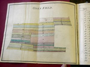
Some idea of the importance of Methley in 1379 can be assessed when the Poll Tax levied by Richard II for war in France (returned Methley as xxxvis) which was shortly to lead to Wat Tyler and the Peasants Revolt. Comparable figures for the neighbourhood were :- Huddersfield xixs. ivd., Lofthouse viiis. vid., Rothwell xls. ijd. Castleford xvs. xf., Swillington xxxs. ivd.
We shall take a peep at how the village developed through the next 400 years by recording extracts from the Thoresby Society book the ‘History of Methley’ and other sources including a survey completed in 1773 which identifies the three field system at that time and is hardly likely to have changed very much since the early middle ages. Material sources are from Castleford Library and West Yorkshire Archives.