The map below is undated – but would be about 1800. It is obviously incomplete with no reference to any structures in Mickletown, and a school to the west of Moss Carr?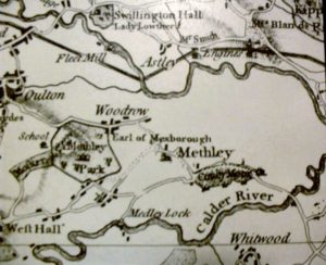
Solved – A cut out from the the Yorkshire Evening News (date unknown) reveals the following explanation :- In answer to a query from Mr P Curtis of Pit Lane, Methley who wrote to say that he would like to see a map of Methley before 1830. The same map from which this is a section was copied by the newspaper. Their published reply was that it was taken from the Jeffries map of Yorkshire published in 1775 and reproduced from the original in the Brotherton Library of Leeds University by Harry Margary, Lympne Castle, Kent. It still doesnt explain the omission of housing in Mickletown of which there must surely have been some at that time.