I am indebted to Chris Lowe for allowing me to publish the following record of a walk that he made on the 11th August 2017. Chris and his family it would appear, reside in Abu Dhabi (I believe he is a teacher there), at the moment I am unable to say where he hails from. I’m sure he will let me know! And so he has now confirmed that he comes from Cheshire. And his connection to this part of the country – he was lucky enough to marry a lass from Cas.
For the last couple of weeks we have been based in Castleford and some friends of ours came up to see us for a few days. They wanted to see some local highlights and I was determined to see parts of this town that I had heard about over the last fifteen years or so but never actually visited so I spent many hours pouring over google maps to establish a circular walk that would take in as much of the natural beauty and industrial heritage as possible.
I had heard a great deal over the years about Methley Village but never actually been there so I determined that that place would be our first port of call.
Beginning in Glasshoughton might have meant a walk along the busy Leeds Road but I noted that a new cycle trail was being developed which we could pick up at Cutskye, near the sadly now closed Castleford Swimming Pool.
It was unclear from a prolonged internet search whether or not the path was fully open but we took the gamble. The path follows a disused railway line that once connected Methley with the main east coast line to London via the Cutsyke Junction but it would be fair to say that this initial stretch isn’t the most picturesque of strolls. After a mile or so the path forks left and right and the signposts have disappeared – we were fortunate enough to be able to ask some local youths who refrained from behaving stereotypically and helpfully pointed out that we should take the fork to the right. We did.
Unfortunately, this meant forking off the railway line and towards the Leeds Road, the A639, at Whitwood Mere. It is possible that had we double backed to the left just before Merewood Road, we may have been able to rejoin the path but there were no signposts and so we made our way to the River Calder.
From the road bridge it is possible to look west and see the old railway bridge crossing about 500 metres upstream and I guessed that we could walk along the Calder to the old railway bridge but again, there were no signs so it was a bit of a gamble. The gamble paid off but we had to scramble up the well hidden path up the side of the bridge to rejoin the cycle path and cross what was Stephenson’s Bridge. This bridge looks like it has been renovated but the rest of the path, both heading towards Castleford and into Methley was in poor condition – walkable certainly, but in need of some care and attention.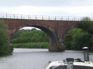
From Stephenson’s bridge you can look westwards towards Altofts and tell your guests the sad tale of John Illingworth – which can be found here. Obviously I did. Incidentally, I spent a good few hours examining the Castleford and Pontefract Express to find out what happened to Alfred Beaumont who was accused of Illingworth’s murder. As yet, I haven’t found the answer!
The path eventually leads to what I assume was known as Methley Junction. The old station house has been turned into a very pleasant looking home and several bridges suggest a variety of train lines that once ran through here. Again, though there is no alternative but to leave the path and head this time, into a new housing development and then back on to the Leeds Road.
It is short walk though, then the lovely Saint Oswald’s Church. Sadly the church has obviously suffered a little recently and it no longer seems to be open during the day unless the Vicar is present. This as a real shame as I am reliable informed (by the internet) that the Church houses the tomb of the first Earl of Mexboro – the local Lords of the Manor – and of warriors from the Battle of Towton. The churchyard was in need to some care and attention and I was delighted to see two little ladies giving it some though I rather felt that they faced an uphill battle. It is a shame that whilst Methley has grown and grown over the years, the new residents seem to have rather neglected this splendid piece of their community’s history.
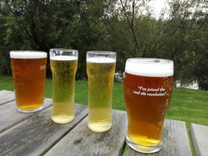
Marvellously, Saint Oswald’s is next door to a pub – The Boundary House – which serves great looking pork pies and a fine selection of local beers. I went for one that is perhaps not so local but brought back happy memories of my university days – the Lancaster Bomber.
Resisting the temptation to take the rest of the day off and stay in the pub, we strolled along Little Church Lane, a lovely street running alongside the Bowls and Cricket club and headed towards the main part of the new village on Church Lane. We passed the Methley Warriors Rugby League grounds before turning left into Station Road, another reminder no doubt of Methley’s links with the locomotive years. Here the scene is one of new development in the form a new housing estate, reminders of the past in the form the Methley Mining Memorial and of the reclamation by nature of old industrial grounds as the old Saville Coal mine has been turned into a nature reserve with cycle paths criss-crossing the area. We crossed the River Aire here over a new footbridge and headed back along the river towards the Saint Aidan’s nature reserve and Allerton Bywater village.
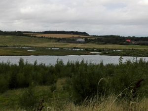
Saint Aidan’s lakes were created when the Aire burst its banks back in 1988 causing so much water to flood into what were then coal mines, that the river actually ran upstream for a time while the water level settled again. Today the place is a peaceful nature reserve with only ‘Oddball’, the giant drag line machine that dragged coal to the surface serving as a reminder of the industry that took place here.
I wanted to take the river path all the way back to the Boat Pub at Allerton Bywater but there are a range of paths and we took the wrong one, ending up in Allerton Bywater village itself. If you want to follow the river, follow signs for Lowther Lake. Our path brought us out at King Edward Avenue, right next to the Fish and Chip shop so we had to walk along the road back to the river. There was a sign-posted path back to the river which eventually pops out into the village at the Victoria Pub but we were bound for the Boat so carried on along the Main Street and found our destination easily enough. This time, a pint of the wonderfully local Castleford Tiger was on the menu…..
Looking back towards Allerton Bywater (above) and the River Aire
Turning left out of the pub put us back onto the riverside path and this led us to the point at which the Calder and Aire meet and where the Aire and Calder Navigation cut in the late 17th century, cuts across the northern end of the town.
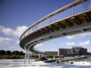
The metal bridge over the Navigation is no longer fit for human boots so you have to walk along the Navigation to the road bridge and then double back on yourself. It’s worth it though because walking along the river eventually brings to you the Castleford Footbridge, a fine new crossing opened in 2006 and a centrepiece of the town’s redevelopment plans. 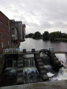 From here you get a fine view of the old Allinsons Flour Mill and of the weir which is still home to a rusty old boat that freed itself from its moorings back in the 50’s and failed to make it over the fast flowing obstacle.

The Old Bridge
Allinson’s. Bread wi’ nowt taken out.
Crossing the bridge allows the walker to ponder over heritage, industry, development, re-development. This town has seen a great deal of growth and decline and change and has had periods of triumph, of conflict and now, hope for the future. The river will be a big part of that if only the planners have the foresight to use it well.
Our walk took us about 5 hours. But that included a couple of pub stops……..